More than two and a half years ago, a group of 11 Water utility companies located in Barcelona metropolitan region – Aigües de Banyoles, S.A, Aigües de Castellbisbal, S.A, Aigües de Figueres, S.A., Aigües de Girona, Salt i Sarriá de Ter, S.A, Aigües de Vic, S.A., Consorci d’Aigües de Tarragona, Proveïments d’Aigua, S.A., Aigües de Mataró, SABEMSA, Aigües de Blanes, S.A., Aigües del Prat, S.A. – decided to use Giswater as a corporative tool and its development team started to work on the version 3 of Giswater.
After a huge amount of work of the whole team, thanks to the confidence of the Water utilities and thanks to the incredible effort done by the PostgreSQL, PostGIS and QGIS teams, the Giswater project has successfully released the Giswater 3.3 version.
Now, not only 11 water utility companies from Barcelona’s metropolitan region use Giswater. More than two million of inhabitants, besides Catalonia, are managed by utilities that use Giswater as a corporate tool. New projects are starting now, and as far as I know lots will be starting in a short-term.
Small and medium water utilities know, that
by using Giswater, they can share knowledge, and sharing is one of the best
ways to face the water industry digitization challenges. Because of that,
Giswater is the perfect tool for those companies that have this profile. Acting
as a know-how driven software, the knowledge from all utilities is shared by
implementing that know-how as a workflow button.
A huge refactor has been done from initial
requirements provided on the 3.0 to the current version. It is with great
pleasure that we share all this knowledge and provide, as a result, a nice tool
and we hope you will love it!
Therefore, the main streams of this new version are:
- 100% compatible with QGIS3
- 100% compatible with PostgreSQL from 9.5 to 11.x
- First version of API fully developed in PostgreSQL, PostGIS
- Java is deprecated. Finally, you don’t need to install JRE from Oracle. We are now Java free.
- Continuous code improvement not only in terms of python, but also database.
As a result, a lot of improvements have been done. Hereafter we explain it:
Huge reduction of the number of layers in ‘ToC’
Before this version, lots of layers had been stored on ToC and used as a value domain tables for fields on the other tables, using the custom forms approach of QGIS. Thanks to the API of Giswater, no layers need to be stored on QGIS projects. Value domains are provided by API and updated using the notification channel between PostgreSQL and QGIS. The use of ‘notify’ against QGIS and PostgreSQL was published by Oslandia here: http://oslandia.com/en/2017/10/07/refresh-your-maps-from-postgresql/. Thank you Oslandia for your work. Here you can find a short video:
https://youtu.be/7PZOkPSBlus
New Giswater info button
A new button on the Giswater toolbars has
been created. This one has a total control over what is shown to the user. As a
result, 100% customizable forms are available.
On the database you can configure the
position of ‘widgets’, label them, enable them or not, hide them, etc. All is
configurable. Here you can find a short video: https://youtu.be/Np5BKmaupiQ
New load ‘custom layer’
In order to facilitate the work of GIS specialists, we have implemented a button to load custom layers, that can be used on projects where the layers are not present. The button shows custom layers, sets and updates widgets properties using the notify approach. Here you can find a short video: https://youtu.be/dpxCMr870BY
System layers are now deprecated on QGIS projects
Custom layers were implemented on 3.1 of Giswater, but there were no user’s interface tools to facilitate the creation, update and use of the custom layers. On this 3.3 version, the user interface, allows to create, update and delete custom layers, as well as the custom fields have been developed. Concerning custom layers, they have more capabilities than system layers, as it does not make sense to use system layers on QGIS projects. Here you can find a short video: https://youtu.be/heyNdyjzkiI
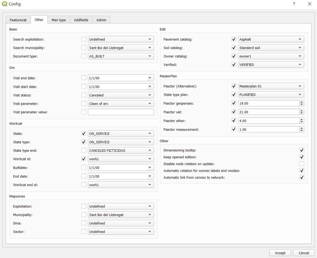
New config button
Thanks to the newly developed API, a total
refactor of the ‘config’ button has been done. Using the getconfig and
setconfig, it’s very simple to manage and escalate. Besides, a nice config
button has been designed to be fully scalable and configurable, thus becoming
more dynamic and much more user-friendly. Here you can find a short video: https://youtu.be/BkSwVYqdjV8
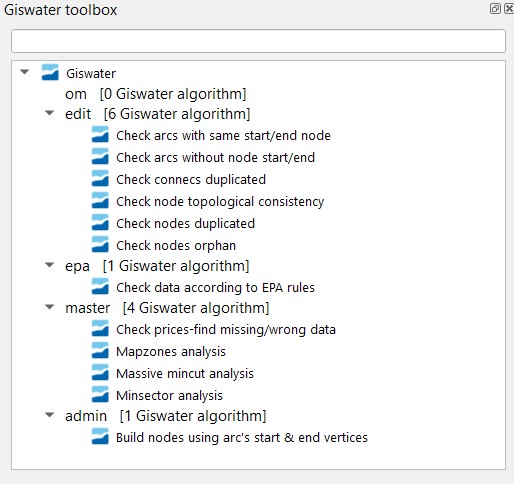
New toolbox button
Thanks again to the newly developed API, a
total refactor of the ‘toolbox form’ has been done, becoming fully dynamic and
much more user-friendly. These tools have the possibility to be used with many
more options than before.
Special attention for the graph analytics functions developed for water supply networks. After configuring it, it’s possible to sectorize networks using a dynamic strategy as you have never seen before. District meter areas (DMA), Presszone (PRESSZONE), inlet areas (SECTOR), District Quality Areas (DQA) and minimum sector (MINSECTOR) are identified using dynamic strategy using a super-fast graph algorithm developed by Enric Amat from Aigües de Figueres, S.A. water company. Thanks a lot, Enric for this amazing algorithm. Here you can find a short video: https://youtu.be/hgY9QPU8GOM
Manage large GIS working teams
With Giswater 3.3 it is possible to manage large GIS working teams. It is aimed to those companies that manage lots of exploitation aggregated into management areas with different working teams. Now users can work only with those exploitations to which they are assigned. This feature has been implemented in order to meet the requirements of CPS Engenharia and Gipuzkoako Ur Kontsortzioa. This short video https://youtu.be/OaBM4fJl_NY shows the configuration process.
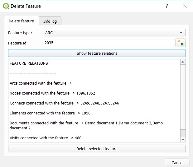
New button forces delete feature
A new button to force the deletion of
feature has been developed. Due to many restrictions and constrains in the
database it’s not easy to delete anything. If the user uses this button, it
will warn about the dependencies and constrains found in a database but
deleting a feature will be possible because all of these constrains will be
temporary disabled.
As far as you know this is a dangerous capability, so use it with caution. The video https://youtu.be/rNSXXBlY1G0 shows the configuration process.
Enhanced double-geometric gully capabilities
Due to requirements from Aigües de Blanes, S.A, new capabilities managing polygon geometry of gullys have been implemented. Now it’s possible to insert a double-geometric sinks using not only the size from the grate catalog, but also a configurable scale factor. In addition, geometry is created using the azimuth of conduit to which it’s connected (parent arc_id). Here you can find a short video https://youtu.be/qN3RkXB_GqU
Read INP SWMM and EPANET files
Reading INF files is one of the most
demanded features since the first release on 2014. Some attempts have been done
before, including one guy from Catalonia Polytechnical University (UPC). He developed an amazing approach to read INP
problems, but his computer burnt after finishing the process, without any
backup saved on the external drive!!!
In this case, this tool has been possible thanks to the collaboration of ABM, Serveis d’enginyeria i consulting SLU. Big files may crash due to performance issues, and the DEV team is working on that. We hope that in the next releases we will be able to improve this feature a lot. Moreover, there is an interesting possibility to import flow regulators such as #giswater node2arc. Here you can find a short video: https://youtu.be/G31bHYmWERI
Improvements on EPANET network export capabilities
Now it’s possible to generate an INP file by
breaking pipes with all connecs, if vnode-link exists. This capability enables
the hydraulic engineer to make fine models with higher precision and better
results. In addition, there are no mandatory nodearcs – shut-off valves might
be exported as node or as nodearc. As a result, the combo of export network type
has now four possibilities to export networks to Epanet:
- Only mandatory nodearc
- All nodearcs, it includes thousands of shut-off valves when the network is a little bit big.
- Trimmed arcs, using vnode-link approach and only with mandatory nodearcs
- Full detailed network, trimming arcs with vnode and with all nodearcs from the network
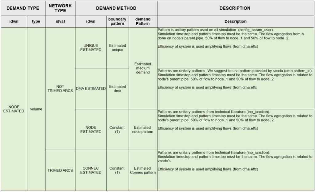
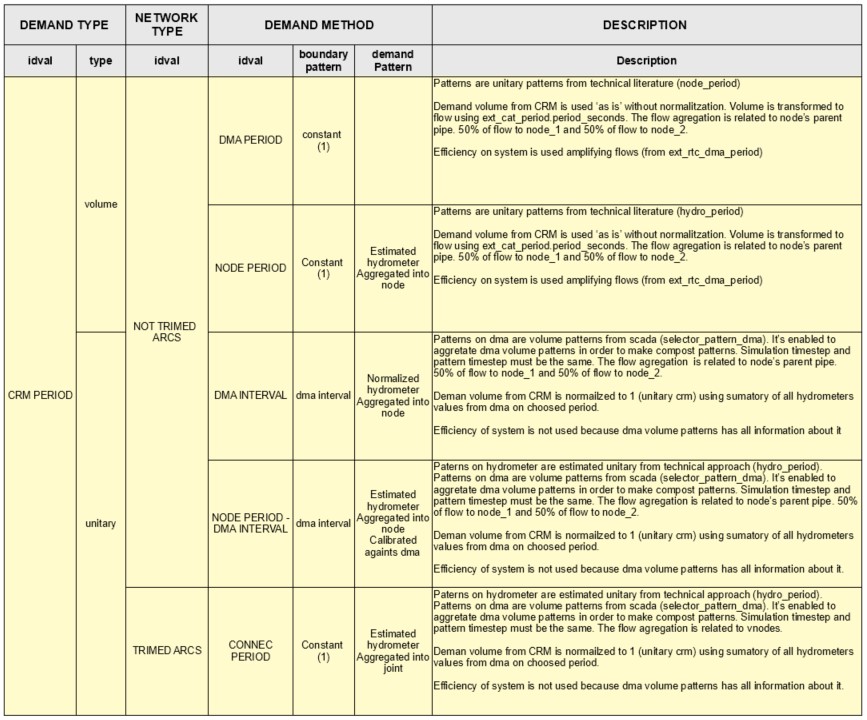
In addition, pattern methods and demand
types are available to make better hydraulic simulations. Here you can find a
detailed option with all export combinations you can work with:
Let me say that the options 3 and 4 will
only succeed if the pattern method chosen is one of the two pattern methods
that manages patterns from connecs. As you can see, it does not make sense to
use the trimmed arcs followed by the node pattern method strategy.
This nice improvement has been done thanks to the requirement of Gipuzkoako Ur Kontsortzioa, Aigües de Blanes, S.A, Aigües de Manresa. Here you can find a little video: https://youtu.be/nzRO4jusuyc
New Epa-type ‘inlet’ for water networks
Before 3.3, fictitious Sectors (‘border
sectors’) needed to be used on WS projects when EPA files were created using
the multi-sector approach of Giswater in order to manage border node elements
like valves or junctions. From 3.3, you don’t need the borders sectors approach
anymore. As a result, the new Epa-type has been created (inlet), that will be a
‘reservoir’, if it acts as a header of the network (only one outlet pipe), or
it will be a ‘tank’ if it acts as an intermediate inlet (at least one inlet pipe
and one outlet pipe). The election is done automatically when the INP file is
created without any user’s action, allowing the dynamic sectorization. Here you
can find a short video: https://youtu.be/YWAmRoE_pmM
Outlet may be an array of nodes and Subcatchments
Now subcatchments on urban drainage projects may have an ‘array’ of pairs (such as ‘nodes’ or other ‘subcatchments’), depending on the planned alternative they are working with. The election is done automatically when the INP file is created without any user’s action, which allows dynamic outlet definition. Never more than one outlet will be set. This improvement has been done thanks to the requirement of Aigües de Manresa. Here you can find a short video: https://youtu.be/8rQJxqkE7Bc
Automatic switch from junction to outfall on urban drainage networks
Before 3.3, fictitious Sectors (‘border sectors’) for UD projects had to be used, just like on WS projects when EPA files were created. If not, it wasn’t possible to manage the multi-sector approach of Giswater, where you were able to manage border node elements like junctions or outfalls. With 3.3 version, you don’t need the borders sectors approach anymore. To work with this, the ‘junctions’ of UD sanitation projects may be transformed into ‘outfalls’ if they only have entry conduits without exit ones. Here you can find a short video: https://youtu.be/oDKxVX13GEQ
Improvements of INP export inconsistent values
When the INP file is being created, many
things must be checked in order to enable an automatic run of the EPANET
command line. Each Giswater version has more checks to facilitate the work of
the hydraulic engineer. In this version, according to the improvements of the
network geometry, the pattern method and the demand type, lots of checks have
been created. Here you can find a short video: https://youtu.be/3c1JLM5x9rw
Now connects (connecs and gullies) may be also planned
In this version, you can plan, using alternative approaches, not only arcs and nodes but also connecs and gullies. In addition, the multi arc_id parent is available. Same connect may have different parents in function of the alternative chosen by the user. In case of conflict, only one parent will be enabled. This feature has been requested by Aigües de Manresa, Aigües de Mataró, Aigües de Vic, S.A.. Here you can find a short video: https://youtu.be/K3K2X6TFzbU
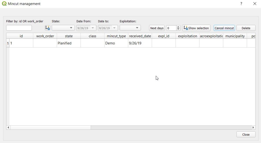
Mincut enhancements
Little improvements to manage mincut have been developed. Now, the user is able to visualize specific mincuts in a selected space of time, manage the possibility of canceling mincuts and also send text message notifications to the subscribers. Requirements have been done by FISERSA and Aigües de Vic, S.A.. Here you can find a short video: https://youtu.be/k5XgrA5LBQM
New GUI tools to manage custom fields and custom features
For admin users, a tool to manage custom fields and custom features is absolutely mandatory. Finally, on this 3.3 version, it is possible to manage not only ‘custom’ fields, but also custom features and visit class. This is great because it facilitates the work of the system administrator. The feature has been requested by Aigües de Mataró. Here you can find a short video: https://youtu.be/-DG8URZ3pY8
Giswater 3.3 has many more things. Only a synthesis of its capabilities has been shared. Feel free to use and distribute it.
Thank you so much to the Giswater dev team, QGIS dev team, PostgreSQL dev team and PostGIS dev team for an amazing work you have done! Without you nothing of this would be possible!
God save PostgreSQL, PostGIS and QGIS!
Enjoy Giswater 3.3!